Smoke from Yosemite fire brings unhealthy air to area

The air quality in Reno and the surrounding region have been affected by the smoke blowing its direction from the Yosemite Rim Fire.

As Reno’s great August smoke-out continues, one of the area’s top atmospheric scientists warns that people should take seriously the danger of breathing the dirty air.

But Alan Gertler of the Desert Research Institute also said folks should view the situation in the proper perspective. Decades ago, air pollution at levels now being experienced in Reno was common in some American cities and remains common today in cities around the world — places such as Beijing, Shanghai and Cairo.

“This is what L.A. used to be like in the ’70s all the time,” said Gertler, vice president of research and chief science officer at the Desert Research Institute.

“These levels are pretty severe for the U.S., but this is a good day for a lot of the cities in the world,” Gertler said. “That says a lot about how far we’ve come.”

The problem affecting the air of Reno-Sparks, Carson City, Lake Tahoe and other places across the region comes not from smog-belching traffic and heavy industry but from smoke blowing into the area from major wildfires. Over recent days, the biggest smoke-producer is a massive blaze burning in and around Yosemite National Park. Earlier in the month, unhealthy levels of smoke blew into the Truckee Meadows from a different fire west of Tahoe.

After welcome winds brought a brief reprieve Sunday — clearing enough smoke for air quality to improve to the moderate range — conditions deteriorated again Monday. By late in the morning, Reno’s air quality index measured 160, well into the range in which the air is considered unhealthy for everybody. By contrast, particulate pollution in Beijing topped out over the previous 24 hours at 185.

Yosemite’s Rim Fire is 20% contained after burning 250 square miles. At least 23 structures have been destroyed and 4,500 are threatened, according to the California Department of Forestry and Fire Protection. More than 3,750 firefighters were battling the blaze, aided by 15 helicopters and 460 fire engines. With forecasts calling for winds to continue blowing toward Reno from the southwest, the smoke is expected to remain.

“As long as we keep any kind of southerly flow to it, it’s going to funnel smoke into here,” said Dawn Johnson, a meteorologist with the National Weather Service in Reno.

Health officials are urging people — particularly children, the elderly and anyone suffering from heart or respiratory disease — to minimize contact with smoke and avoid strenuous outdoor activity.

Levels of fine particulates measured in Reno’s air in recent days are roughly twice acceptable standards, and those tiniest particles are the ones most dangerous to human health, Gertler said.

“It knocks days off your life. If you look at the exposure, you have a number of populations that are at risk,” Gertler said. “It really is a pretty bad-case scenario for us.”

via Smoke from Yosemite fire brings unhealthy air to area.

Posted in Air Quality, USA & Canada | Tagged , , , , , , | Leave a comment

Respro® Masks FAQ: Are the filters interchangeable?

FILTER IN MASKARE THE FILTERS INTERCHANGEABLE?

The filters in City™, Sportsta™, Techno™, Cinqro™ and Respro® Allergy™ masks are interchangeable provided they are the same size. i.e. large City™ filter will fit in a large Cinqro™ mask.

For more FAQ,  see Respro® Mask FAQ


Posted in Air Quality | Tagged | Leave a comment

Air Quality Monitoring In South Africa Improved With Satellites

SA

Economic development often means an increase of harmful gases into the atmosphere. ESA’s GlobEmission project uses satellite data to monitor atmospheric pollution from emissions.

South Africa’s economy is rapidly growing. From 2002 to 2012, its gross domestic product grew by about 270 billion US dollars. Unfortunately, a strong economy often leads to high levels of air pollutants – which can influence regional air quality and can have an impact on global climate change.

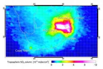
Over the industrialised Highveld region, satellites show concentrations of the air pollutant nitrogen dioxide comparable to those observed in Europe, eastern North America and south-east Asia. With such high levels of air pollution, it is important to monitor the emissions that cause them.

Emission inventories are used to describe the location and magnitude of emissions from various origins, such as traffic, forest fires or industry. These inventories are then used for scientific atmospheric models, as well as by policy makers to evaluate the effectiveness of air quality improvement initiatives and decide on future strategies.

Emission inventories are usually compiled from large amounts of statistical data, but are limited by the lack of continuity. Furthermore, events such as forest fires or extreme weather are not taken into account. In addition, economic developments – such as recession or the closing of factories – directly affect atmospheric composition but are not accounted for by common emission inventories.

Earth observation satellite observations, however, can provide consistent data on atmospheric composition for improved emissions inventories. For a closer look, ESA began the GlobEmission project to focus on emissions for four specific regions: China, India, Europe and South Africa.

“In GlobEmission, we use state-of-the-art satellite measurements and computer models to calculate the measured air pollutant concentrations back to their origins,” said Dr Ronald van der A, leader of the GlobEmission project.

“The advantages of these emission estimates are their spatial consistency and high temporal resolution. Above all, they are rapidly available because there is no more need to wait for the newest release of statistical data.”

At the Dutch meteorological institute KNMI, Dr Bas Mijling works on improving regional emission estimates using nitrogen dioxide observations from the GOME-2 instrument on Eumetsat’s MetOp satellite and the OMI instrument on NASA’s Aura. He was surprised to see such a large difference between the estimated emissions values for South Africa’s Highveld region and actual values from the satellites.

“The old inventory was especially wrong about the location and strength of emissions by power plants and heavy industry. Using satellite data, however, we can correct their location and update their emission to actual values,” he explained.

A next step in the GlobEmission project is being taken by the Belgian company VITO, who will refine the South African emission values by using statistical information on population density, traffic and land use.

Furthermore, emissions from wildfires, forests and agricultural land use will also be taken into account. All information will be made available on the GlobEmission website.

The Department of Environmental Affairs of South Africa is already planning to use this new emission inventory to improve their emission monitoring programme.

Results of emission inventories derived from satellite observations will be presented to users and potential users in December at ESA’s ESRIN centre in Frascati, Italy. In the same workshop, users will show the use of these data in their daily work.

via Air Quality Monitoring In South Africa Improved With Satellites – Science News – redOrbit.

Posted in Africa, Air Quality | Tagged , , , , | Leave a comment

Air Quality Monitors To Be Installed To Measure Vehicle Pollution On SoCal Freeways

Federal regulators will install four monitors to test air pollution levels near freeways in Southern California and study the impact of vehicle exhaust.

KNX 1070′s Pete Demetriou reports the tests could shed light on potential health risks to an estimated one million Southland residents who live within 300 feet of a freeway.

Starting in January, two of the four air pollution monitors will be installed along the 10 Freeway in the Inland Empire and along the 5 Freeway in Santa Ana. The monitoring devices will study the impacts of pollution on neighborhoods directly adjacent to freeways both in Los Angeles and nearly 100 major U.S. cities.

A 2008 Cal State Fullerton study of L.A., Riverside, Orange and San Bernardino Counties found 3,052 deaths and 2,300 hospital admissions attributed to vehicle exhaust pollution. Among the health risks identified are asthma, bronchitis, low birth weight, autism and lung and brain cancers.

“What are we going to do about siting new homes and new schools next to freeways?” said Angela Johnson Meszaros, general counsel for Physicians for Social Responsibility Los Angeles (PSRLA), one of the groups that sued the Environmental Protection Agency (EPA) to force the upcoming monitoring.

“We sued, demanding that the EPA require those monitors so we can start making movement toward cleaning up the air,” said Meszaros.

East L.A. resident Jeannette Soriano, who lives within 300 feet of a freeway, supports the study.

“We need to monitor these areas because we need the information, we need the data to then make changes,” said Soriano.

Many believe the monitors will show higher pollution levels, prompting the EPA to issue new regulations, including stricter restrictions on emissions.

“We will not be able to meet the new federal particulate standard right away,” said Sam Atwood of the Air Quality Management District (AQMD). “We will have to work out additional emission reduction strategies.”

via Air Quality Monitors To Be Installed To Measure Vehicle Pollution On SoCal Freeways « CBS Los Angeles.

Posted in Air Quality, USA & Canada | Tagged , , , , , , , , , | Leave a comment

Poor air quality is still a problem for our towns

Poor air quality caused by traffic is still a problem in Warwick, Leamington and Kenilworth.

Exhaust from cars is the worst contributor to Warwick, which is a quarter higher than national pollution guidelines.

Richard Hall, Warwick District Council’s head of health and community protection, admitted that originally it was assumed heavy goods vehicles and buses would be responsible for most emissions of nitrogen dioxide in places like Jury Street and High Street,But, in fact, domestic diesel exhaust from cars driving in and out of town is the main culprit.

The Low Emissions Zone study has also been carried out on busy roads in Leamington and Kenilworth.In the High Street and Clemens Street area of Leamington the fumes from exhausts were recorded as 44 microgrammes in the first part of this year, compared with 46 last year, 48 in 2011 and 36 in 2010.On the Parade the level was 44 microgrammes this year, compared with 37 last year, 37 in 2011 and 24 in 2010.In Kenilworth the area studied was the main 
Warwick Road.

Emissions there have been recorded as above the national guidelines both for the first part of this year when they were 44 microgrammes – the same as 2012.In 2011 records were 43 micogrammes, a huge leap up from 2010 when they were just 29.

The results should build a stronger case for Park and Ride schemes and cycle lanes.A new report, just released to district councillors, shows that Warwick’s air quality measured between Jury Street and Theatre Street – as well as a second site near St John’s Church – was ten microgrammes per metre cube higher than nationally recommended levels.

Although Mr Hall points out that this does not necessarily mean the air is unsafe to breathe.The latest raw figures for his Low Emissions Zone study show air quality from January to June this year was 50 microgrammes per metre cube.

This is lower than the 53 microgrammes recorded in 2012; and the 58.2 recorded in 2011.

Mr Hall said: “Domestic diesel fuel is the main culprit but with the increasing efficiency of engines the level of emissions has come down.

“What our report shows is that simply banning HGV vehicles from a town is not going to improve air quality – instead we need to look at ways of reducing the number of cars.

“In Warwick, as in other towns, enclosed streets are the reasons the levels of nitrogen dioxide build up.

“These levels only extend for a short distance and can quickly disperse.”

Hampton Street, next to the racecourse, was registered as 42 microgrammes last year but only 36 in the first six months of this year.

Members of the Warwick Society submitted a Freedom of Information request to gain access to the report as soon as it became available.Increasing air pollution is one of their key arguments against the thousands of extra homes being considered in the Revised District Plan.

via Poor air quality is still a problem for our towns – Local News – Leamington Courier.

Posted in Air Quality, UK | Tagged , , , , , | Leave a comment

Respro® Sportsta™ Mask Review by Living In The Big Ring

Sportsta™Here in Arizona there are huge dust storms that will be arriving soon this summer. The literal walls of dust are picked up and carried all over. It makes driving and seeing very difficult. Visibility is drastically reduced. It is in these dust storms, or “haboobs” ,a fungal disease known as Valley Fever is carried. I try not ride or run when these types of storms are present. I have been packing along just in case a Respro® Sportsta™ Mask, to help keep my lungs and respiratory system healthy while out training. Whether running, road or mountain bike riding. I have used it several times while out mountain bike riding, as the dust off of the wheel of the person in front of you and sometimes your own tires kick up this dust. The device simply covers your mouth and nose filtering the air while allowing you to breathe normally. The soft neoprene is attached behind your neck with a Velcro enclosure. The devices are made in the U.K. Of course drinking while out training while wearing this device is impossible. However, I suggest if you need to take a drink while wearing it, simply stop remove the mask, drink, and carry on. Around the nose there is a metal clip, keeping the mask securely tight around your nose. You will notice on the mask there are two valves in the front, these are where exhales air escapes from, however as you inhale, the air you bring into your lungs is totally filtered.

via Living in the BIG RING: Respro® Sportsta™ Mask.

Posted in Respro® Mask Reviews | Leave a comment

Hong Kong Haze Pollution: Typhoon Trami Traps Air Pollutants, Gov’t Issues Health Warning

Hong Kong may not be directly affected by severe tropical storm Trami, which is currently battering China, but it surely still made its presence felt in the country. Trami’s coverage was so wide that it trapped pollutants in Hong Kong’s air to reach “very high” levels, prompting the government to issue health warnings.

“Because of the typhoon, we don’t have any wind, the air now is like static, pollutants accumulate and they can’t get out,” Kwong Sum-yin, chief executive officer at Clean Air Network, a non-profit advocacy group, told Bloomberg. “Central is pretty bad, exactly because we have so many skyscrapers.”

“The high air pollution incident is a result of the trapping of local pollutants, in particular nitrogen dioxide, in the territory under the light wind,” Hong Kong’s Environmental Protection Department said.

On Thursday, pollution indexes breached the 100 limit – it was 174 at roadside-monitoring stations in the Central business district, 184 in the commercial district Causeway Bay and 167 at Mong Kok.

Once readings breach the 100 line, government immediately alerts its people, especially those with heart or respiratory illness, to stay away from heavy-traffic areas.

Between 9 and 10 am, the visibility in the Central business district dropped to 1,500 metres.

“The light wind condition and intense sunlight favoured the photochemical smog in the region, resulting in the high regional background pollution,” Dave Ho Tak-yin, principal environmental officer, was quoted by the South China Morning Post.

“The high air pollution incident is a result of the trapping of local pollutants, in particular nitrogen dioxide, in the territory under the light wind coupled with the relatively high regional background pollution,” he added.

Trami, with torrential rain and winds of up to 120 kilometres per hour, dumped its full force early on Thursday in China’s Fujian province.

Tourists currently in Hong Kong who wanted to snap the coastal city’s famous skyline were forced to use fake backdrops featuring the skyline captured on a rare, pollution-free sunny day to serve as souvenir of their visit.

Measuring 3 meters high by 15 meters wide (10ft by 50ft), the backdrops show a picture-postcard-perfect panorama of Hong Kong Island’s central area taken from one of the popular sightseeing areas across Victoria Harbour.

“We did take pictures over there [with the actual harbour view]. But it is too foggy today,” Australian Dallas Seager told the South China Morning Post. “We couldn’t see the architecture [on Hong Kong Island] clearly.”

As of 7 pm local time on Thursday evening, Hong Kong’s air quality index was at 152, still considered “unhealthy.”

via Hong Kong Haze Pollution: Typhoon Trami Traps Air Pollutants, Gov’t Issues Health Warning.

Posted in Air Quality, Asia, China | Tagged , , , | Leave a comment

Air pollution monitoring stations face closure as government looks to cut costs

Up to 600 stations for monitoring air pollution across England could be shut down under new government plans to save money by cutting regulations.

Ministers want to remove obligations on local authorities to assess air quality in their areas, resulting in less monitoring. But environmental campaigners are accusing them of trying to hide one of the country’s biggest public health problems.

Government advisers have estimated that one type of pollutant – miniscule particles from diesel engines, fossil fuel power stations and other sources – is killing 29,000 people a year in the UK, and costing health services about £16bn.

But European air pollution limits meant to protect health are being breached in urban areas across the country, with the highest levels in London. According to the Department for Environment Food and Rural Affairs (Defra), the limits for the toxic exhaust gas, nitrogen dioxide, were exceeded in 40 of the UK’s 43 air quality zones in 2010.

But now Defra has launched a six-week consultation, due to close on 30 August, proposing a radical overhaul of the local air quality management regime that has been in place since 1997. The proposals are aimed at helping meet ministers’ “red tape challenge” to roll back legislation in order to help businesses.

The favoured option is to drop existing requirements for councils to make detailed assessments of air pollution. Defra’s analysis shows that this could lead to the closure of 600 monitoring sites, all of which measure nitrogen dioxide and a quarter of which also test for pollution from tiny particles.

The closures could save councils nearly £50m over 10 years, Defra suggests. The proposals only apply to England, and have been rejected by the Scottish government on the grounds that they “would deliver no obvious benefit”.

“The UK government wants to hide air pollution and cares nothing for public health,” said Simon Birkett, director of the campaign group, Clean Air in London. He points out that the consultation is taking place in the summer holidays and describes the financial saving as illusory.

He added: “Worse, the changes would mean the loss of key protections in the planning system and the very monitors and expertise needed now to improve air quality.”

Prof Duncan Laxen, the managing director of Air Quality Consultants in Bristol, said that much of our understanding of air pollution has come from local authority monitoring: “It will be a retrograde step if the government’s preferred option is to lose this local knowledge.”

Defra insisted that the aim is to “reinvigorate and refocus” local air quality management. It said that the current regime was “diagnosis driven” and that “the level of local reporting can distract resources from air quality improvement”.

via Air pollution monitoring stations face closure as government looks to cut costs | Environment | theguardian.com.

Posted in Air Quality, London, UK | Tagged , , , , | Leave a comment